
By Alana Mauger
The American Red Cross joins the National Weather Service (NWS) in observing Severe Weather Awareness Week in Pennsylvania April 15-19, 2024. The educational campaign aims to inform the public about how to prepare for and respond to severe weather events like thunderstorms, flash flooding and tornadoes.
Severe Thunderstorms
A thunderstorm is considered severe if it produces wind gusts of at least 58 miles an hour or hail stones that are about the size of a quarter. These storms are usually accompanied by heavy rain, lightening and possible tornadoes.
NWS issues watches and warnings to alert the public about severe weather risks.
- A severe thunderstorm watch is issued when conditions in the atmosphere are favorable for thunderstorms with damaging winds and large hail to develop in a geographic region. If a watch is issued for your area, consider rescheduling outdoor activities and check for updates throughout the day.
- A severe thunderstorm warning means a severe thunderstorm is happening or is about to happen at your location soon. Warnings typically last less than an hour and may list specific towns that are in the storm’s path. If a severe thunderstorm warning is issued for your area, seek shelter inside immediately and go to an interior room on the lowest level. If you’re driving, pull over to the side of the road until the storm passes.
Outlooks, Watches and Warnings
Watches and warnings can be issued for any severe weather event and apply to the flash flooding and tornado sections below.
In addition to watches and warnings, NWS issues a convective outlook 1-8 days ahead of severe weather to predict the risk for broad regions. Categories of risk include general thunderstorms, marginal, slight, enhanced, moderate and high. The higher the risk, the greater potential for intense and widespread severe storms.
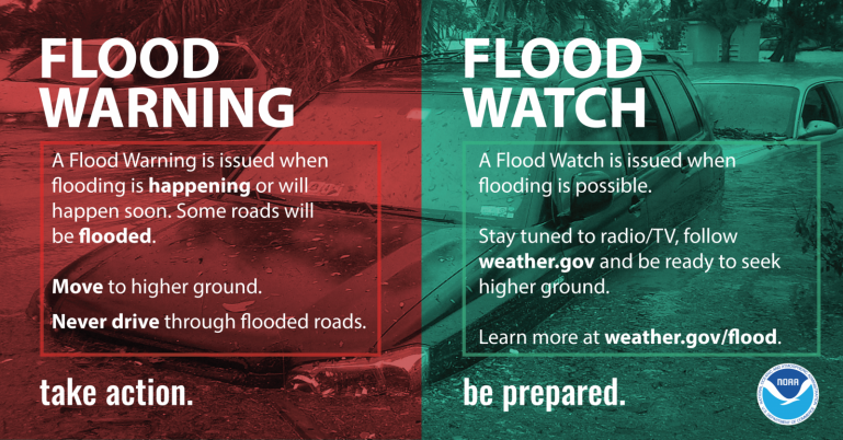
Flash Flooding
Unfortunately, more people are killed by flash floods than by other storm-related weather hazard, with most deaths caused by driving on flooded roads. A flash flood is flooding that happens quickly. During a flash flood, streams, creeks or manmade drainage systems rise rapidly and crest within a few hours as a result of heavy rain. They’re so dangerous because the water rises quickly and can catch people off guard and trap them in dangerous situations.
If you encounter a flooded road, TURN AROUND, DON’T DROWN! Don’t drive or walk through flooded areas. It takes only 6 inches of water to knock you off your feet, and 16 inches of water to move a vehicle. Get to higher ground outside of the area prone to flooding and stay informed by monitoring weather alerts. Pay attention to flood warnings and watches.
Tornadoes
A tornado is a violently rotating column of air in contact with the ground. Wind speeds inside a tornado can range from just under 100 to 300 MPH and can travel as fast as 70 MPH. While Pennsylvania is at a lower risk for tornadoes than areas in the mid-west, they do occur here. In fact, the commonwealth averages around 15 tornadoes per year.
If a tornado warning is issued for your community, seek shelter in a basement or interior room on the lowest floor. Closets, bathrooms, and other interior rooms without windows offer the best protection. Avoid windows and get under something sturdy or cover yourself with a mattress. If you’re at a school, hospital or shopping center, follow directions to a pre-designated shelter area.
If you’re in a vehicle, buckle your seat belt, and try to drive to the closest sturdy shelter. If your vehicle is hit by flying debris while you are driving, pull over and park. Stay in the car with the seat belt on. Put your head down below the windows, cover your head with your hands and a blanket, coat or other cushion if possible.
Stay Informed
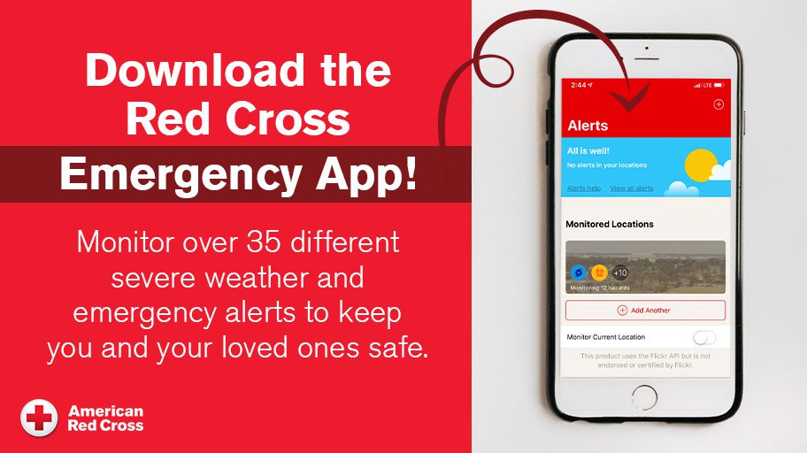
The Red Cross provides a free Emergency App for real-time alerts and proactive planning. This app has been delivering timely and reliable storm emergency information to affected communities since 2015 and was updated last year with new features that provide modern accessibility, customization, and proactive planning guidance. Download it from any app store or visit our website.
Climate Crisis
The climate crisis has led the Red Cross to respond to nearly twice as many large disasters compared to a decade ago. In 2023 alone, the U.S. experienced an all-time high of 28 billion-dollar plus disasters that ravaged communities and forced hundreds of thousands of people to flee from severe storms, floods and wildfires.
With the growing frequency and intensity of disasters driven by the climate crisis, the Red Cross is racing to adapt its services and grow its disaster response capacity across the country. Visit our Climate Crisis webpage to learn more.
